come ON already... geesh...
Posted Sep 15, 2006 · 01:54 UTC#2
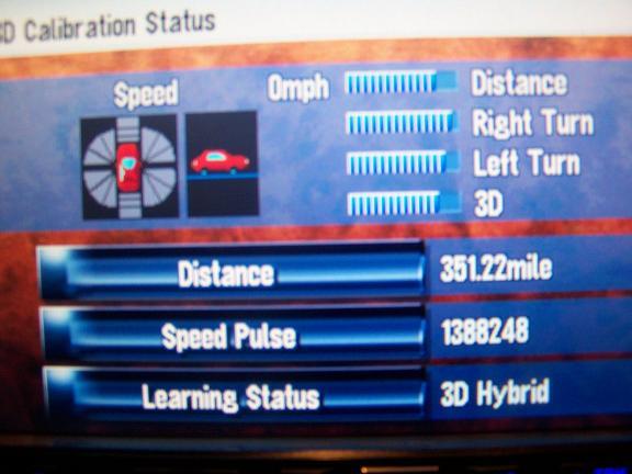
If your learning status line says "simple hybrid" then you have no 3D. 3D Hybrid is the best it gets, the bar graphs show you the relative difference between the states. I don't think they will ever "fill up" unless you do all 4 of those equally. I think those are more relative as opposed to absolute measurements.
Posted Sep 15, 2006 · 02:09 UTC#3
IT took my d1 almost 1000 miles before the learning status maxed out.
Posted Sep 15, 2006 · 02:27 UTC#4
ducatiboy said:If your learning status line says "simple hybrid"...
mmmm, i dont think it ever said that, maybe i missed it
Posted Sep 15, 2006 · 15:04 UTC#5
What does the 3D do anyway?
Posted Sep 15, 2006 · 15:14 UTC#6
Corey497 said:mmmm, i dont think it ever said that, maybe i missed it
I believe it does, but it goes away in about 50 miles (usually), if you want to reset all your "learning" it will go back to simple hybrid and you can see. :)
Posted Sep 15, 2006 · 15:22 UTC#7
Interceptor said:What does the 3D do anyway?
Short answer, it will know if you are going up a hill or down one.
Long answer: Since there are internal accelerometers, it can sence a force in all directions. It always feels the force of gravity down, when you accelerate forward, it can sense the force of you moving forward. So when you go through a tunnel, it can sense if you are speeding up or slowing down without actually knowing the speed of the vehicle, it can get an idea if you change your velocity (speed up and slow down or if you change direction). This is simple hybrid. I think it relies on these less in this mode. Then if you stop at a stop sign on a very steep incline, you will be angled up and the accelerometers will feel a force backwards (gravity) but it can't tell that from acceletation. The GPS signal doesn't change but it doesn't have an instant speed measurement, so I think it just doesn't take the accelerometer measurements in to account as much in this mode. I think it does more left and right changes as opposed to forward and backward changes.
If you have your VSS wire hooked up it knows exactly how fast the car is going (after it learns how many pulses equates to MPH). After a while it calibrates itself to the speed of the car and the measurements of the accelerometers. NOW if you stop at a stop sign on a very steep incline, you will be angled up and the accelerometers will feel a force backwards (gravity) but with the VSS wire hooked up it KNOWS that you are stationary, so any force backward it uses to calculate as an incline not acceleration (and vice versa for a decline).
I believe that's the jist of it.
Posted Sep 15, 2006 · 19:43 UTC#8
I may be wrong, but I thought the short answer is:
When going through a tunnel or in an other areas where the GPS signal is lost (like around tall buildings or trees) It can still, somewhat, continue tracking which roads you're on and the turns you make without an interruption. Using the VSS and other sensors that Ducatiboy mentioned to determine position... And after reading Ducatiboy's post again I think this is what he was getting at.
When going through a tunnel or in an other areas where the GPS signal is lost (like around tall buildings or trees) It can still, somewhat, continue tracking which roads you're on and the turns you make without an interruption. Using the VSS and other sensors that Ducatiboy mentioned to determine position... And after reading Ducatiboy's post again I think this is what he was getting at.
Posted Sep 15, 2006 · 20:09 UTC#9
I think simple hybrid means that it uses the accelerometers to help determine position when there are no gps signals (like in a tunnel) but more of a 2D use of the accelerometers, forward and backward and left and right. This happens right away and works like MitchellStang mentioned.
The "3D" portion which Interceptor asked about can be only utililized when you connect a VSS signal and it's calibrated and I believe adds a "vertical" dimention... up a hill and down a hill.
Not that the screen has any more than 2D anyway, the nav system still knows you are on an incline or a downward slope.
My guess this helps it determine more accurate speed. If you were driving down a 45 deg incline going 60 MPH, not all of your motion on the map would be in 2D, only a % of that is forward momentium based on an ariel view. Like from a Sat view of you in this situation you would be moving only 30 MPH, not 60 since some of your motion is directed downward. Not that many of us drive on 45 deg slopes, but it's just an example to exagerate the point.
I believe that this 3D component, when available is just added accuracy.
Posted Sep 16, 2006 · 16:36 UTC#10
what about the display? you guys are talking about the 3 dementions, X-Y-Z. I understand what your saying about that, but i noticed that as the 3D builds more stuff is showing up. For example, on a road that has grass on the side of it, grass is shown on the drivers view of the map as well as restarants which looks like an old 50's diner.....
Posted Sep 16, 2006 · 18:14 UTC#11
Interceptor said:What does the 3D do anyway?
Having used various GPS navigation for a long time now (the better part of a decade), normally "3D" navigation is when the GPS is able to get a fix on enough satelites to generate a three dimensional location fix for the X,Y, and Z axis. Using this, it can more accurately determine your position on the map because not only does it have a 2D X,Y triangulation, but also the 3D axis that gives it "Altitude". So in this case, using that altitude attribute, it can make the map more accurate and display more information.
Now, that being said, I'm not sure the AVIC-Z1 manual describes it this way, because they do also have accelerometers that provide a “dead reckoning” ability to the navigation unit. However, I’ve noticed quite a few technical and other inconsistencies in the manual, so I’m left wondering if the person(s) who wrote it fully understand the technology they were describing. As ducatiboy described the use of the accelerometers, the Z1 uses them to make approximate determinations of direction, movement and speed if everything is working correctly, but they can be confused by steep terrain or excessive vibration. That is why the speed sensor is so vitally important.
My interpretation in this case would be that 3D hybrid mode simply means the unit has a good GPS fix for 3D navigation (in the traditional X,Y,Z sense), and it is also taking measurements from the internal accelerometers and speed sensor into account when it plots vehicle location on the map.