

mgreinke
-
Content Count
26 -
Joined
-
Last visited
Content Type
Profiles
Forums
Blogs
Gallery
Posts posted by mgreinke
-
-
Are speedcam warning popups working in this version? In the emulator at least, I only see the speedcam icons appear on the road.
-
Has anyone had any luck using navigation.near_speed_limit [or] navigation.over_speed_limit successfully? I've been testing these in the emulator but even when these variables should be TRUE, nothing seems to work.
-
Thanks for the advise. I will check it out. In the mean time does anyone have any specifics?
Thanks
Check ui_pioneer\common\ui\navigatemap.ui
-
You need to have some computer savy and see http://avic411.com/forum/viewtopic.php?f=34&t=26742&p=183917&hilit=navtec#p183917
-
Thanks for all of the assistance... I was able to get the speed limit sign to appear while in a route which is what I wanted. However it would be nice to have the speed limit sign appear on the screen even when im not in a route.
I placed the following code under the Navigation_800_480.ui text file.
;Display Posted Speed Limit
Hopefully its just something that I missed.
Thanks
The code looks right but my guess is you have inserted in a layer that is only active when you have a route active.
Mark
-
Didnt seem to work on the stock 3.0 skin for me with IDT and a few of my simple mods. The signs are still large.
-
I downloaded the images and font and placed the images in the "ui_pioneer/common" folder and added the font to the igo folder.
Where exactly did you place that section of code?
I tried both the orginal 2.0 code and your example code under the navigatemap_800_480.ui. placed the code under the section and when I turn on the navi or run it in the emulator the current clock speed icon does not appear on the screen nor does the elevation sign.
I set the clocked speed and elevation signs to only show when the GPS has a valid signal. If you are using the emulator without a working GPS unit the signs will never display. You can remove &gps.valid from those two lines if you want the signs to show even when no GPS is valid.
Mark
-
Got a question for ya IDT. Who is responsible for the implementation of the "Can't make a left/right turn" sign that appears on the right side of the unit? I am guessing that is is a function of the iGO software implementation than your mod. I am wondering because I have run into quite a few situations where it is completely wrong and is more a distraction than help. Is there a way to remove that? Thanks.
Funny you should mention the turn restrictions. I updated to 3.01 Thursday evening and have been adding back some mods. This one I added it into my mod over the weekend and it's very unreliable. No where near the accuracy of the previous map files. I was going down a street in Chicago today that every other street is an opposite no left/no right turn street. The display kept telling no left turn on virtually every street for about a mile stretch.
Just comment out the code in the navigatmap800_480 ui file. It should have a reference to turn restrictions in the code.
Interesting. I was driving in Portland OR today and noticed every one way street was showing a turn restriction in the wrong direction from the actual restriction. I tried commenting out that code but got a recoverable error on boot up saying something like the script was undefined. I went ahead a modified the turnrestriction.bmp to swap the left and right no-turn signs. Will have to do some more driving to see if this works better in my area.
-
How do you get the skies to display?
Mine only does the diagonal view from above where there is no horizon line.
You have to add tilt settings to your sys file.
Ok if you guys want skies on your 3.0 unit here is how: Copy and replace the attached sys file in my flash disk/apl2/igo.
Then go into your data.zip file and replace the gfx file with the one also provided in the zip file attached.
Then you have to modify each scheme color.ini and color3d.ini. Copy and paste this code below, under [other] all the way at the bottom in the color.ini files.
background_picture_0="gfx/day/cs.bmp"
sun_picture_0 = "gfx/day/sp.bmp"
This code just shows where the files are for the background to be displayed so you can actually pick other bmp's to use. The one above is for a day background, so you would have to use "gfx/night/whatever bmp for night you want to use"
Have fun modding!

What sys file are you referring to? I dont see any sys file in sky.zip Also, the zip file you attached has tons of other files. Do you just need to two .bmp files you reference above?
-
Geeze. I should have thought of that. It was set to On. I can only assume the update did this. The problem was only intermittant so time will tell but I bet that does the trick.
Thanks for pointing me the in right direction.
Mark
-
Sorry if this has been asked before. I searched the forum but it only pointed to a backup camera issue which I dont have installed. Is anyone else getting the message "WARNING, IMAGE MAY BE REVERSED" when booting after updating to 3.0? The unit still works fine but the message is annoying.
Thanks,
Mark
-
I realized after re-reading this thread that I didn't change the sys.txt file. I changed the show_speed_value to 1 and stil have no change in showing the actual speed limit on any street.. main street, highway, side street, etc.
Most likely reason is that you live in an area of the US that iGo simply does not report the posted speed limit. I havent been able to determine what their posted speed limit coverage is on a given map. Where I live, iGo only reports speeds on the highways; which in itself is practically useless for me too. It would be much more valuable on side streets where the posted speed limit isnt always obvious. I've heard their coverage in Europe is much better than the US.
-
paQ,
I see what you are saying... You are correct, the code I provided to remove the ROUTE INFO display when no route is selected, has the unintended side effect of forcing you to display distance_to_destination, time_to_destination and current_speed when a route IS selected.
The stock code seems to pick up variable set in the AVIC UI so that it can be changed by the UI.
If I was better at coding this stuff I would know a simple way to just turn off the ROUTE INFO display when no route is selected and keep it unchanged when a route IS selected. The sample code I used doesnt really do this. I will see if I can find out how to do what we all want. That is to only turn off the ROUTE INFO display, when no route is selected.
Sorry about all this folks.
-
Sorry if I didnt post correct info. I started with an early version of Mav's mods. I could post my full DATA.ZIP but then you wouldnt have all of Mav's mods.
Here is the entire layer which removes the ROUTE INFO display when not navigating and also adds the Speed Limit, Elevation and Your Speed displays.
If this works, I will fix the first post and remove the incorrect data posted later on.
; start hidden
hide
;end hidden
;Speed limit
;Elevation
;Your Speed
To remove the Map Scale, open up and search through the code of every file in the DATA/ui_pioneer/common/ui folder in the DATA.zip file. The following code should be changed as follows EVERYWHERE it appears. From the best I can tell, this is in navigatemap.ui [and] browsemap.ui:
Replace this:
Code:
map.ZOOMCONTROL_SHOW 1
with this
Code:
map.ZOOMCONTROL_SHOW 0
-
[updated 3/4/09]
I've updated the first post to address this issue.
Sorry about the mix-up.
-
Give these a try. I didnt try them myself. Since the circle would need to have transparancy, hopefully I have that correct. I'm sure you will also need to adjust the X/Y coordinates to make the numbers fit.
Good luck!

-
The speed limit sign will only display when NO ROUTE is active and then only when driving on a road that iGo reports the speed limit. Where I live, this is on highways only.
Also, the mod YOU are using when NO ROUTE is active, will certainly overlap with the speed limit sign using the X/Y coordinates in the sample script. You will need to use alternate coordinates if you dont want this to happen.
Lastly, if you dont use the DSDIGI font file I provided, then you will need to modify the line which references this font to reference the TAHOMA font.
Good luck!
-
You are right BorisM and thanks for responding. They do store some form of speed limit data which can be viewed when you add that setting to SYS.TXT. It certainly isnt posted speed limit info. The display you get (along side the road name when you tap the screen over a road) is something like 26/?50. Not sure what that is but not very usable. I did a little googling and from what I can tell, the maps iGo uses these days dont have many posted speed limits for US surface streets (they did some time ago). Seems that they still have fairly good coverage in Europe. I agree the iGo folks may be hesitant to display the posted speed limit if they get adjusted every so often however Garmin doesnt seem to care, at least in my part of the US.
Thanks again!
-
It's a shame that the iGo maps have such skimpy speed limit coverage in the US. I need to hop on a freeway in order to see any posted speed limits. I confirmed it isnt any better with the 2008.4 North America maps. Garmin on the other hand displays speed limits for all my local surface streets. I would have thought that iGo would need this data in order to calculate an ETA for a route.
-
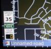
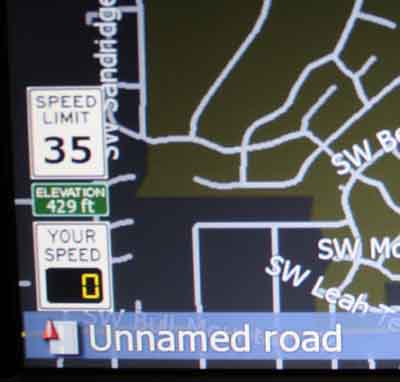
US Speed and Elevation Road Signs...
[uPDATED 3/4/09 to assist with removing the Route Info and Map Zoom displays so they dont overlap with the road signs. Note that step #3, will turn off the route info display when no route is selected however when a route IS selected, the route info display will be fixed to show distance to destination, time to destination and current speed. Still looking for code to allow you to set these variables through the AVIC interface]
1) Copy the (3) bitmap files in the ZIP file to \ui_pioneer\common. These are the various road sign templates. You may want to make a backup of speed.bmp. I'm not sure if this stock speed.bmp is even used on the F series.
2) Copy the DSDIGI.TTF file to \My Flash Disk\APL2\iGo on your F series. Note: This is an alternate font used for the digital display on the "your speed" sign. You can stick with the stock fonts but if you do, you will need to change it back to tahoma or tahomabd in navigatemap_800_480.ui.
3) If you are using the stock navigatemap_800_480, you will notice that the ROUTE INFO display will show when not navigating and this will be a waste of precious screen realestate. If you are already using a script like Mavrickster's, this has already been removed for you. If not, you will probably want to turn off this off. This also will allow the various road signs to not overlap the ROUTE INFO display. If you are already using Mavricksters mods, you can skip to step 4.
To turn off the ROUTE INFO display when not navigating, replace all the code in the section as with this code:
; start hidden
hide
;end hidden
4) To also remove the Map Scale, open up DATA\ui_pioneer\common\ui\navigatemap.ui and seach and replace all references of
map.ZOOMCONTROL_SHOW 1
with
map.ZOOMCONTROL_SHOW 0
Do the same thing for DATA\ui_pioneer\common\ui\browsemap.ui
4) To display the posted speed limit, place the following code in navigatemap_800_480.ui in the same layer as noted in step 3 (). Insert this code at the bottom, just before the statement:
;Display Posted Speed Limit
5) To display your elevation, add the following code in the same layer (again, just before the statement:
;Display Elevation
6) To display your clocked speed, add the following code in the same layer (again, just before the statement:
;Display Clocked Speed
Many thanks to those who have gone before me to show the way....
-
Another modified theme...

-
Either the Speed Limit Mod isnt working correctly or the stock iGo doesnt know the speed limit on many roads around where I live. Garmin (using LeetLauncher v2.0) however has no problem displaying the posted speed limit.
-
Awesome Dude! Thank you. I'll give it a try.
-
Do all the button press mods require that the unit first be bypassed (either hardware or parking break ground)?


Custom Mustang background request please
in Custom Backgrounds
Posted