

evotronix
-
Content Count
12 -
Joined
-
Last visited
Content Type
Profiles
Forums
Blogs
Gallery
Posts posted by evotronix
-
-
It is kind of exciting to see these models, I like the detachable face F310BT. And correct me if I am wrong but this looks like a different version of IGo that the new models are running, so I am speculating here, but it just may be possible that we can benefit our older units with some new software...
 or at least ideas. Anyway, My F700 BT still looks better than all of them with the CMH928 AIO mod on.
-
Thanks for the quick reply CMH928!
So I assume I should put the already extracted maps in MiTACAP\APL2\iGo\CONTENT and create "maps" folder there right?
I am already running the 2008.4 maps, but just want to do it this way because it seems easier, I want to re-upload the maps because I think the ones on the unit right now are corrupt.
Thanks again for the info!
-
Hi, I have a quick question -
Is it possible to drop all the new maps I have into the AIO and have it install them for me?
I did it manually, but it took pretty long, and I think some were corrupt and now the unit is acting up - rebooting, getting stuck and thing like that, this was before I installed the AIO, so I think it was bad map files.
Also, what should I change in sys.txt for a F700BT? I switched the data.zip with the noMSN one, anything else?
Thanks for the awesome mod and all the help guys, this is a great thing you are doing! Without this forum, this unit wouldn't be nowhere as cool, or useful!
-
Please guys, I would be very grateful if anyone points me in the direction of the latest North America maps... I am google-ing
 , and t-ent searching and I gave up, can't find 'em
  . Anyone, just pm me if you can't post the link here
Thanks!
-
How about this:
SPEEDO/ALTIMETER/ROUTE INFO MODStep 1: To remove the Map Scale, open up and search through the code of every file in the DATA/ui_pioneer/common/ui folder in the DATA.zip file. The following code should be changed as follows EVERYWHERE it appears:
Replace this:
map.ZOOMCONTROL_SHOW 1
with this
map.ZOOMCONTROL_SHOW 0
Step 2: To replace the Route Info box in the bottom left corner, find the following code in the navigatemap_800_480.ui file in the DATA/ui_pioneer/800_480/ui folder in the DATA.zip file:
and replace the entire thing with the following:
;original three line nav info box
;
;
;
;
;
;
;
;
;
;
;
;
;
;
;modified info box

; start hidden


hide


;end hidden


;


; GPS Status
;


;current speed (and speed limit where present) and altitude when not navigating


;
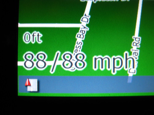
RESULT: This will result in the removal of the Map Scale. This will also result in the removal of the original Route Info Box. When no route is selected, the altitude and speed will appear in the lower left hand corner (when speed limit information is available to the device, it will also show the current speed limit). When a route is selected, a more legible version of the Route Information Box will appear.
Information Displayed when Route not Active:
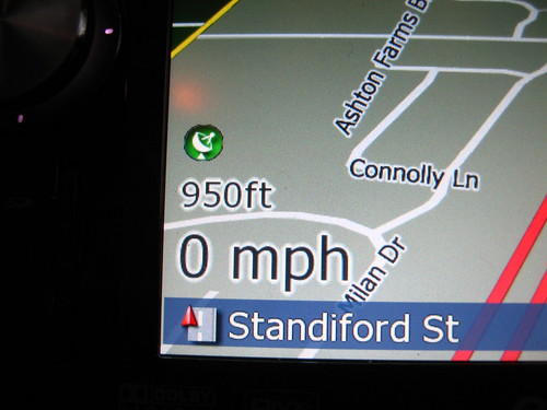
If Speed Limit Information is Available, it looks like this (1st number is current speed; 2nd number is speed limit):
Information Displayed when Route is Active:
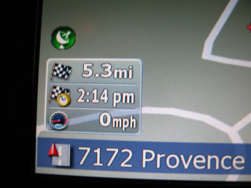
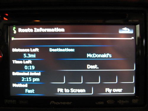
Pressing the Route Info Box brings you to this Route Info Screen:
-
I just want to say:
Great job Mav, thanks for the help and for putting all these great mods together!
-
Hey, first I want to thank Mav for the help getting my GPS button to work (thanks for the sprites man, that solved the problem).
Now I have a question to anyone that can answer me:
I am using linear compass with this code:
;compass
Can I put the detour function on this?
Thanks guys and gals!
-
maybe you can find something here:
Well, yes, that's where I get all these crazy ideas from...
Why not anyway? It is essentially a PC, there's also Windows XP embedded, XP that can run off a flash disk. But looks like Win CE is the best option.
-
You are definitely right about the x86 compatibility, but there are frontends like Roadrunner for example, so what if it could be ported to WinCE, and of course you don't need all the bells and whistles of a full blown carpc, but still, i think it would be nice.
-
Yeah, I don't mean "We should switch to linux, it is better" but rather I think a custom made shell, based on whatever is best will be a good solution, obviously Pioneer has done a real crappy job from what I hear, and the hope that they will fix it remains, but if there is a ready to use solution, why not use it? All these little GPS units use win CE, and they seem to do a fine job, also the car pc scene has tons of frontends and other stuff available.
And I am not by any means programming savvy or anything, just pushing ideas here that's all
-
Hi everyone, new to the forum here.
I have been reading this forum for the past week or so which resulted in me buying an AVIC F700BT, so while I am waiting for my unit and reading about all the possibilities it has to be modded, I was wondering - what about Linux?
There are linux solutions for embedded devices based on the ARM platform, I think linux could offer greater customization options and flexibility. I myself would pay for a new redesigned AVIC software that would make it what it should be - a lean mean CarPC, and most important, faster
.Anyway, I just want to say this is a great forum, with lots of useful info. Thanks guys and gals

peace out.
in Hacks/Mods
Posted
Great work dude! Thank you for all the effort and just want to let you know how much I appreciate what you have done here, for free, to greatly improve this half - baked unit. Thanks to this AIO mod I was able to easily upload updates and fix a bunch of corrupt maps that otherwise were pain in the a** to do, and also now I have a much better and usable NAVI, Thanks to you and all the givers on this forum!